

High Roads Adventure Touring
High Roads Adventure Touring
Climb onto the shoulders of Giants

I am pretty sure when I started Bikepacking Northern Nevada I said I was going to be satisfied with riding the long flat valleys that make up the basins of the Basin and Range. I would be satisfied with the views of the mountains from below and not chase the unknown of what is up high. How long did that last? It is absolutely natural for me to look for the roads over every mountain range. Now I want to ride into each canyon to see what it hides. Note: I looked through my early writing I could not find any reference to being satisfied by riding in the valleys. But the memory is so strong. I must have had that conversation with myself as I was huffing and puffing riding uphill.
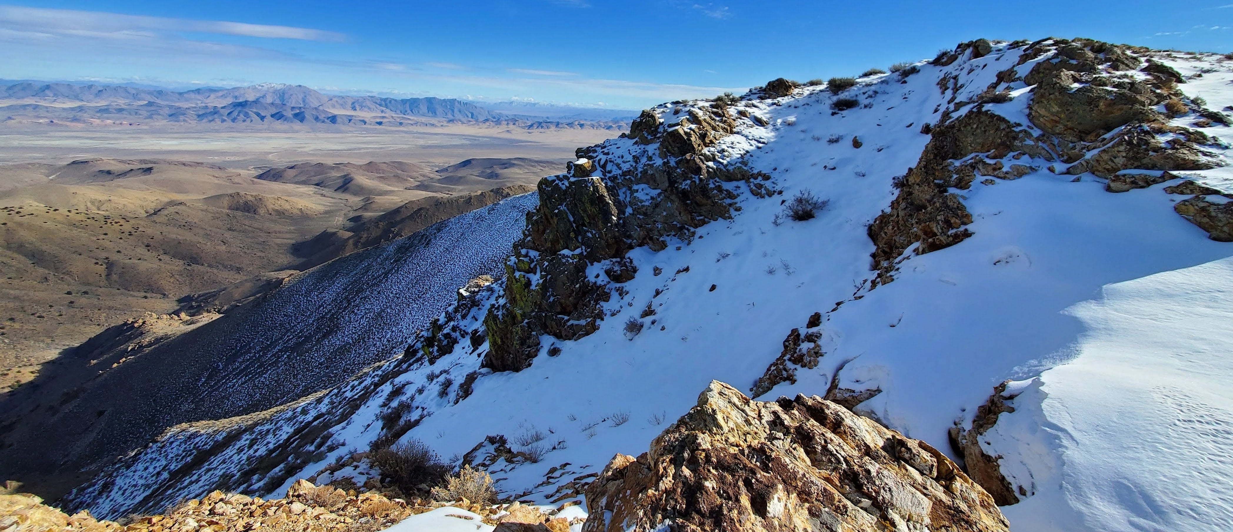
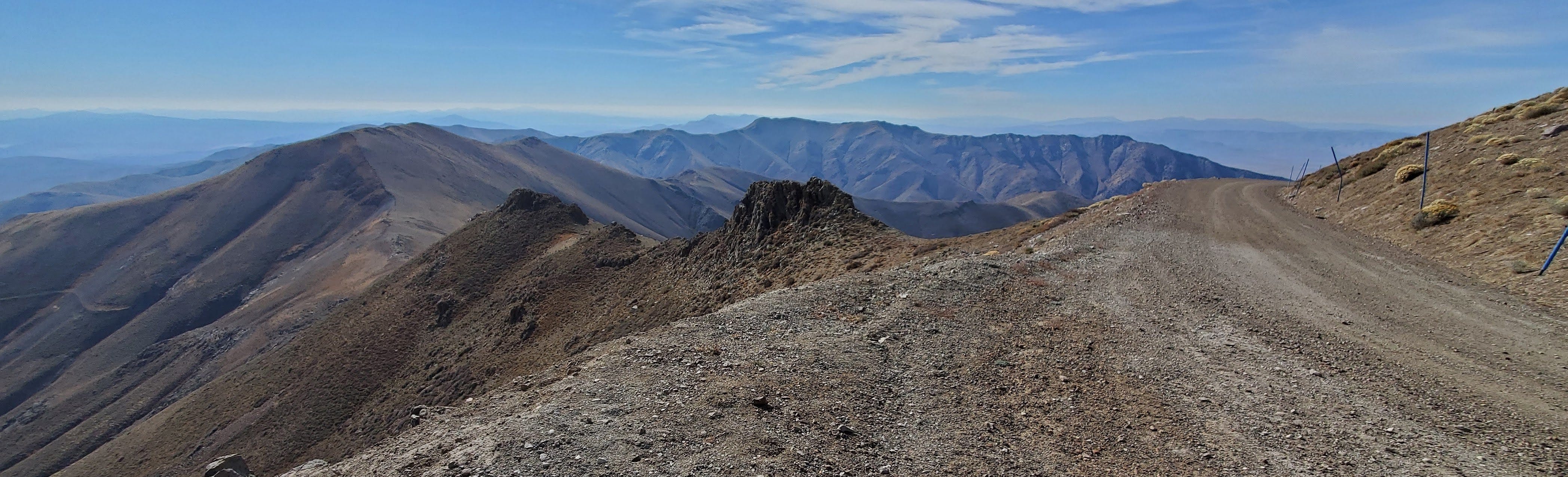
A few years ago I started a High Roads Project. My criterion was looking for roads above 9,000’ in elevation. This designation is absolutely arbitrary. I think I came to it because 8,000’ was a bit too common so I landed on 9,000’ as the next unit. I was also looking for what is the highest road, and looking for cooler destinations to beat the summer heat. I felt as if 7,000’ wasn’t much cooler, 8,000’ was getting there, and 9-10,000’ would be pleasant in the heat of summer. And then there is the physical challenge of riding uphill for thousands of feet and at elevations with a bit thinner air.
Route finding to these rare high places is a challenge. As someone who enjoys pouring over maps then driving off to test a proposed route this was a great project. High roads make for great adventure travel and here is how I do it.
Nevada is a land of mountain ranges, 300+ in Nevada’s Great Basin. It boasts the most peaks above 10,000’ in the lower 48. It also boasts high concentrations of federally managed public land primarily but not exclusively by the BLM and USFS. Although wilderness posses challenges to mechanized travel your solitude is all but guaranteed on alpine pack trails in North America’s greatest cold desert.
Maps, Radio Towers, Fire Cameras, Lookout Towers, the Internet and Friend Sourcing
When I first landed on this project I made some internet inquiries as to the highest roads in Nevada. I got some lists from a few sources but none were definitive or exhaustive and it seemed like a basic question. I assumed the Nevada Department of Transportation would have this information but not that I could find. Similarly I’ve tried to find the “longest gravel road” but I may have to use satellite view maps to figure this out on my own. But I did get a helpful map from Marc P. He made me a map of “islands above 9000’” and radio towers. Now I had red outlines on Google Earth and points that should have service roads to them. I also got a tip on using the wildfire cameras not only to see what are the conditions in the area, snow covered or not, or bad air quality during fire season or clear, but each camera listing has a map, coordinates and elevation. I always appreciate suggestions and recommendations. In contrast to the many cameras, Nevada has only three fire lookout towers. None of them are very high but they are on my list to visit. I have visited several Nevada adjacent towers, notably Babbitt and Sardine. My friend, Squeak, has climbed to the high points in some of Nevada’s counties and most western states. I got some valuable information from her on the Wassuk Range above Walker Lake. Harry Wagner (@harrysituations) has recommended Patterson Peak in the Stillwater Range as a favorite. Patterson is on my summer’s to do list. My last step is to plot my route on Ride with GPS, and then cross reference that plot with as many maps as I can. I avoid wilderness areas, roads through mines and ranches, and I am wary of extended grades above 30%. I note potential sources of surface water but carry plenty for each trip. Your criteria for route planning and navigation will depend on mode of travel but if I can help, please reach out.
Here are the write-ups for the High Roads Project so far:
FS Road 44017 to Toiyabe Crest Trail
Mustang Mountain and Mustang Pass
In the course of writing this I came up with these routes to include this summer:
Bald Mountain, Rattle Snake Hill, Galena Saddle, Mt. Siegel - Pine Nuts > 9k’
New Pass Peak Radio Towers (New Pass Range)
Byers Canyon/Healy Creek (Clan Alpine Mountains)
Silverado Canyon (Sweetwater Mountains)
Angelo Mission Mine (Sweetwater Mountains)
Once I start route planning I can’t help myself.
Advantages of going higher A change of scenery is first and foremost. Even if you are not chasing the highest roads I think about how perspective changes as you climb. On a ride into the Calico Mountains above the Black Rock Desert, from 4000’ to 7000’, I took the time to look out from my surroundings every 500’ in elevation. The high mountains around us quickly became low ridges that no longer blocked our view of the next range, and the next. The desert floor shifted from a single color and texture to a kaleidoscope of color once you could take it all in.
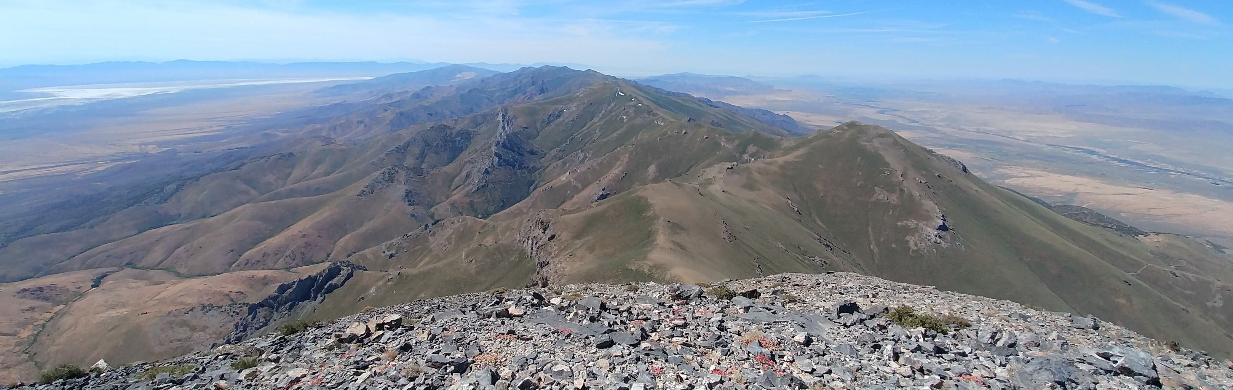
During the summer heat going higher allows you to take advantage of the physical relationship between air pressure and temperature. A day climbing to the summit of Star Peak kept me in the 50’s and 60’s. Very pleasant temperatures. Start just after sunrise. Race the sun as it climbs the sky. I feel the sun’s intensity kick in between 9 and 11. As I climbed the road I even had the occasional shade of pinyon or juniper as well as shade from the orientation of the canyons. At the summit there was a cool breeze. Reaching the lower elevations on the descent I felt like I was in a convection oven as the temperatures were closer to 100. At least I was coasting and headed to my vehicle.

I am always impressed by the extended flower season at higher elevations. Long after the flowers have wilted in the summer heat at lower elevations they are blooming as you climb higher. Along with the flowers are the pollinators ensuring the next generation of flowers. The harsh alpine conditions also select for a particular set of plants you won’t see down low. Biodiversity can be measured on a vertical scale, or on ecological islands separated by inhospitable lowlands.
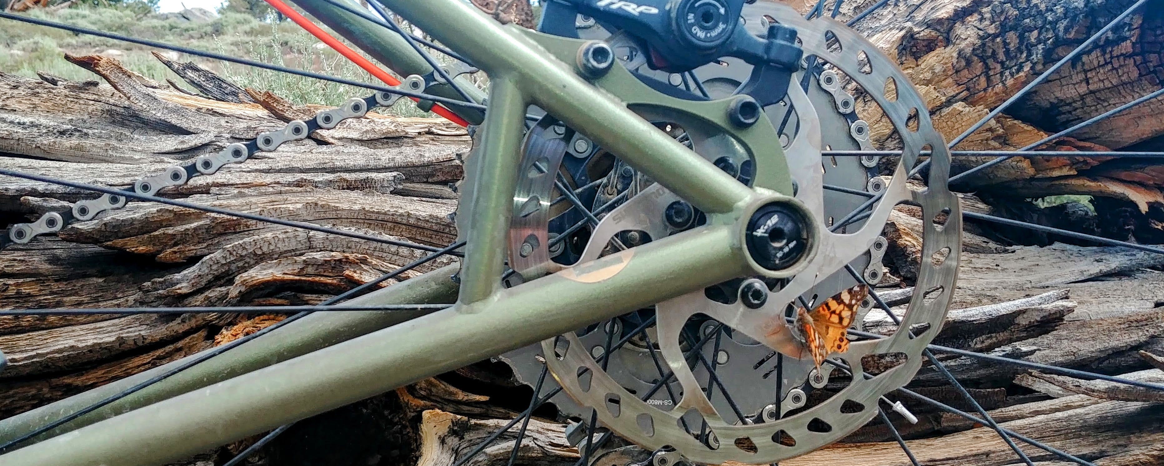
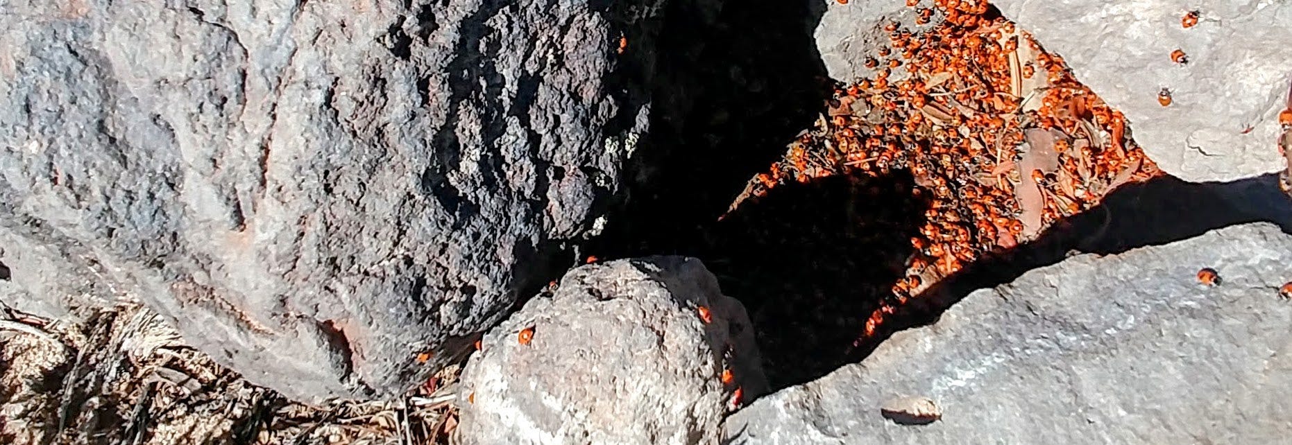
Another biological phenomena to look out for is “hilltopping”. This is a well documented insect mating strategy where mating occurs on a high-point, crest, ridge, butte, or out-cropping. I first experienced hilltopping at the UC Research Field Station in Hopland, CA. I was with Drs. John Anderson and Bob Lane who had described the behavior in deer nasal bot flies and deer flies. That day we observed a variety of flies, butterflies, and dragonflies. From a rock outcrop above Elko I observed the behavior in deer flies. An unrelated but equally awesome phenomena was coming across an overwintering (in late July) cluster of ladybugs (beetles, family: Coccinellidae) near the summit of Mustang Mountain, 10,330’. The clustering behavior in this otherwise solitary insect is thought to be for thermoregulation, mating, defense, and sharing of resources.
Standing on the Shoulders of Giants As with any famous quote it is interesting to see how the words get changed and how its meaning is taken out of context. Without seeing the original letter between Sir Issac Newton and Robert Hooke the quote is, “If I have seen a little further it is by standing on the shoulders of Giants.” This has been taken to explain how scientific advancement is made by small contributions to the current body of knowledge. But I was thinking much more literally when this quote came to mind. Climbing onto the shoulders of Nevada’s giants lets me see a little further. Looking out over the Nevada landscape rekindles that original question, where does that road lead?
Thank you for supporting my storytelling. I hope this gets you out there!
Sources I use in planning high road adventures:
February in Review:
I am finally getting back on the bike as I have beat this respiratory infection. I have sympathy for all those who have gone (going) through it this season whether it was a short illness or protracted. Stay healthy everyone. As a result I logged nearly 2.5X the miles (and trips) as January but have a ways to go to meet my goals. I rode through the Sahwave Mountains, the Stillwater National Wildlife Refuge, and into the Pine Nut Mountains. I am not a hiker, but I love snowshoeing, and made a trip off Carson Pass. I also had a day on the Truckee River fly fishing. I am fortunate to live in a great area where I can take advantage of these outdoor opportunities. In case you missed these posts on Bikepacking Northern Nevada:
Looking ahead:
March is packed with travel unrelated to bike travel. But it will be an adventure! Then April is always a kick-off for bike travel. While I don’t have any April trips on the calendar yet I imagine there will be one or two. May has the Black Rock Rendezvous, which will include touring out to the event via the Smoke Creek Desert. At the event I will lead a short day ride, the Cassidy Mine Loop. I am sure May will have more to offer!
While I was poking around on the web for last month’s Nevada Backroad Festivals I kept seeing a link to Nevada’s historic ranches. My next newsletter will celebrate Cattle in the Cold Desert.